Almora district about 1,640 m
Chitai Golu Devta Temple: Timings, Distance, Nearest Station
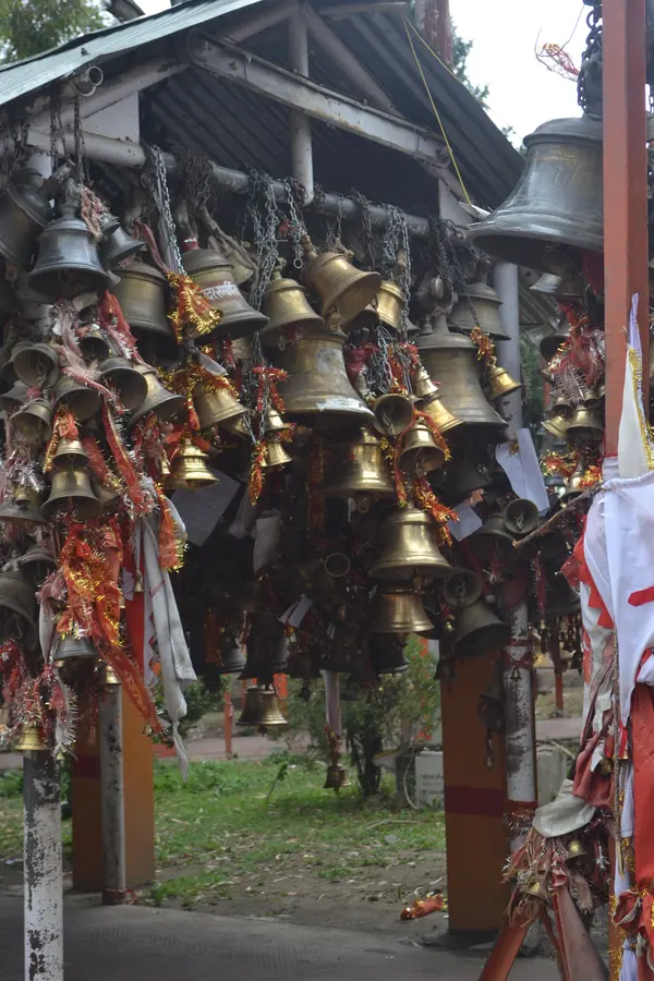
Chitai Golu Devta Temple is a temple 6 km by road from Almora, in Almora district, at about 1,640 m. It is 373 km by road from Delhi and 89 km from Kathgodam railway station, the nearest railway station. Temple of Golu Ji, a Kumaon god of justice, seen as a form of Shiva (Gaur Bhairav). It is known for the copper bells hung all over it.
Chitai Golu Devta Temple at a glance
- Height
- About 1,640 m
- From Delhi
- 373 km by road
- Railway station
- Kathgodam, 89 km
- Airport
- Pithoragarh airport (Naini Saini), 111 km
Visiting Chitai Golu Devta Temple
- One story says a Chand commander built it in the 12th century, with no proof. The present form looks 19th century, and no official builder record is known. (etvbharat.com, 2023-08-31)
Timings
- Opening hours are not published by any official source. (almora.nic.in, last updated 2018-04-13)
Before you go
- Visitors write petitions, often on ₹50/₹100/₹500 stamp paper, and hang them. When a wish is granted they come back and hang a brass bell. (indialegallive.com, 2016-09-05)
- Petitions are marked with vermilion and tied with red thread. Bells are promised by weight and paid for after the wish comes true. (sahapedia.org, not shown)
- Shops near the temple sell bells from about ₹300 to ₹30,000. (etvbharat.com, 2023-08-31)
- A wide bell-lined walkway leads to a small sanctum, often with a slow queue. Locals warn about monkeys. (inditales.com, 2019-12-18)
Lately
- The Chief Minister said the temple is being developed under the Manaskhand Mandir Mala Mission and will be linked to a 'Golu Circuit'. No works or dates given. (punjabkesari.com, 2026-09-23)
How to reach Chitai Golu Devta Temple
By road, measured on OpenStreetMap: 6 km from Almora.
| From | km |
|---|---|
| Delhi | 373 |
| Kathgodam railway station | 89 |
| Tanakpur railway station | 197 |
| Pantnagar airport | 127 |
| Pithoragarh airport (Naini Saini) | 111 |
- About 8 km from Almora (district site); Wikipedia says about 10 km, and 4 km from the Binsar sanctuary main gate. (almora.nic.in, last updated 2018-04-13)
- The temple stands beside NH309B, the Almora–Pithoragarh road, at Chitai. (openstreetmap.org, accessed 2026-10-22)
- Kathgodam is the nearest railway station, about 90 km. (almora.nic.in, last updated 2018-04-13)
The weather near Chitai Golu Devta Temple now
At Almora, 4 km away, at 1,642 m; the temple is at about the same height.
Almora1,642 m
14°CClear
Now, 19:03 IST · wind 4 km/h
- Partly cloudy14° 11°Dry
- Light rain showers21° 8°0.7 mm
- Mostly clear21° 9°Dry
- Mostly clear22° 9°Dry
- Clear22° 9°Dry
- Clear21° 9°Dry
- Clear21° 8°Dry
Forecast for 1,642 m, updated . Data from MET Norway (CC BY 4.0); the daily figures are worked out by us.
Almora weather: the next 24 hours, 10 days and every month.
The snow peaks from Chitai Golu Devta Temple
From the temple's point the elevation model finds a clear line to these summits; mornings from October to March are clearest.
- Nanda Devi, 7,816 m: 88.1 km to the north; about 800 m of it over the nearer hills.
- Kamet, 7,756 m: 145.3 km to the north; about 900 m of it over the nearer hills.
- Nanda Devi East, 7,434 m: 88 km to the north; about 700 m of it over the nearer hills.
- Trishul, 7,120 m: 77.7 km to the north; about 700 m of it over the nearer hills.
- Panchachuli, 6,904 m: 96.5 km to the north-east; about 1,800 m of it over the nearer hills.
- Maiktoli, 6,803 m: 74.8 km to the north; about 1,000 m of it over the nearer hills.
- Nanda Ghunti, 6,309 m: 81.5 km to the north; about 1,300 m of it over the nearer hills.
Where to stay near Chitai Golu Devta Temple

Questions about Chitai Golu Devta Temple
Opening hours are not published by any official source. (Source: almora.nic.in, last updated 2018-04-13.) Times change on festival days; ask locally or on WhatsApp before a long drive.
373 km by road, measured on OpenStreetMap; by train, Kathgodam railway station is 89 km from the temple by road, and Pithoragarh airport (Naini Saini) 111 km.
On the elevation model, the temple's point has a clear line to Nanda Devi (7,816 m, 88.1 km north), Kamet (7,756 m, 145.3 km north), Nanda Devi East (7,434 m, 88 km north), Trishul (7,120 m, 77.7 km north). Mornings from October to March are clearest.
How we made this page
Each fact about the temple names its source, checked 2026-10-21. The point is from OpenStreetMap node/6911691497; the height and the peaks in view are worked out by us on the Copernicus DEM GLO-90; road distances come from OpenStreetMap through the OSRM router. If a timing or rule has changed, tell us on WhatsApp.
About Adi Kailash Explore
Adi Kailash Explore (adikailash.io) is a tour operator based in Pithoragarh, Uttarakhand, that specialises in one route: Adi Kailash and Om Parvat, the Darma valley and Munsiyari. It runs departures from Delhi, Haldwani and Pithoragarh, and its team files the Inner Line Permit for every Adi Kailash traveller at SDM Dharchula. It is recognised by Uttarakhand Tourism, certified by MSME, Govt. of India (UDYAM-UK-09-0012927) and verified on the NIDHI Portal, and was founded by Vinay Verma. Why travel with us
